VANCOUVER — There’s more than meets the eye when it comes to mineral potential in the Canadian Prairie provinces of Alberta, Saskatchewan and Manitoba. Their unique — and often overlooked — geological heritage has fostered a variety of world-class metal districts, and some of the last frontiers for mineral exploration in the country.
Three cratons of the Canadian Shield underpin the Canadian Prairies: the Archean-aged Superior terrane in the east, slightly younger cratons called the Hearne and Rae in the northwest, and remnants of the Paleoproterozoic-aged Trans-Hudson orogen sandwiched in-between.
The terranes, each largely composed of greenstone belts, were sutured together 1.9 billion years ago during the assembly of ancestral North America. At the time, the Trans-Hudson orogen was a vast mountain chain that has since eroded down to its core.
The Paleozoic sedimentary rocks that cover the rest of Manitoba and Saskatchewan pale in comparison to the sediments over much Alberta. Erosion off the neighbouring Canadian Rockies for the past 170 million years — coupled with deposition from ancient seas — has buried the Canadian Shield with sediments up to 5 km thick.
Even to this day, the deep burial transforms any organic layers into oil, which is then moved along with vast groundwater brines for hundreds of kilometres before being caught in impervious traps.
In northern Alberta, extremely permeable quartz-rich sand — sourced from a Ganges-sized river system that spanned Canada 90 million years ago — eventually became today’s prolific oilsands deposits, which are the third-largest oil reserve on the planet.
Four deposit types occur in greenstone belts: base-metal rich volcanogenic massive sulphides (VMS) and magmatic-style deposits from early volcanism, and orogenic or intrusion-related gold systems that formed during deformation. The greenstone belts in Canada are amongst the largest in the world, with equally impressive gold and base-metal contents. In the prairies, they’re also home to world-class uranium deposits and diamond-bearing kimberlite fields, whereas the younger sedimentary platforms are excellent hosts for oil, potash and industrial minerals.

Regional geology of Canada with political boundaries. Credit: The Geological Survey of Canada, modified by The Northern Miner.

Geological cratons underpinning the Canadian Prairies. Credit: The Geological Survey of Canada, modified by The Northern Miner.
Superior
In eastern Manitoba, the 4.3- to 2.5-billion-year-old greenstone belts of the Superior terrane host a variety of metal camps, such as Rice Lake (True North), Bird River and Oxford-Stull.
The belts are similar, if not identical, to those that host the world-class gold and base-metal districts of Ontario. In fact, Klondex Mines’ (TSX: KDX; NYSE-MKT: KLDX), True North gold mine (formerly named Rice Lake) in Manitoba is found 100 km along geological strike of the 31.4 million oz. Red Lake gold district in Ontario.
True North, which has 5.6 million oz. in past production and current resources, is the largest gold deposit that has ever been found in the province, and was the only producing gold mine until recently being put on care and maintenance. The belt is open in the west, where the prospective rocks dip under a veneer of Paleozoic sediments.
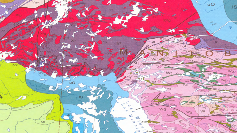
 Geology and metal districts of the Canadian Prairies. Credit: The Geological Survey of Canada, modified by The Northern Miner.
Bird River
South of True North/Rice Lake is Manitoba’s past-producing Dumbarton and Maskwa West magmatic nickel-copper deposits, which are hosted within a 2.7-billion-year-old ultramafic sill complex in the Bird River greenstone belt.
The complex also contains chromite deposits, and before chromite was found in 2008 in northwestern Ontario’s Ring of Fire (ROF), Bird River was Canada’s only chrome camp. Geologists are investigating whether the Bird River and ROF intrusions correlate, considering they’re the same age.
Oxford-Stull
In northeast Manitoba, the Superior terrane hosts the 250 km long Oxford-Stull greenstone belt. The district is most recognized for Yamana Gold’s (TSX: YRI; NYSE: AUY) 3.6 million oz. gold Monument Bay deposit, but it also has granitic pegmatites that are rich with technology metals, such as beryllium, lithium, tantalum and niobium.
Trans-Hudson orogen
Most metal production in the Canadian Prairies comes from deposits within the Trans-Hudson orogen. The most established camp is the long-lived Flin Flon-Snow Lake, one of the largest, Proterozoic-aged VMS districts in the world. The craton also hosts gold, VMS and magmatic-nickel camps, such as Lynn Lake in Manitoba, and La Ronge and Glennie in Saskatchewan.

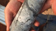
Drill core from Rockcliff Copper’s Snow Lake project in Manitoba. Credit: Rockcliff Copper.
Flin Flon-Snow Lake
The Flin Flon-Snow Lake VMS camp, which straddles the border of Manitoba and Saskatchewan, has produced over 180 million tonnes copper-zinc ore from 31 mines, including the world-class Flin Flon mine, with copper-zinc-gold resources of 62.5 million tonnes of 2.2% copper, 4.1% zinc and 2.7 grams gold.
Three operating mines — 777, Lalor and Reed — all belonging to Hudbay Minerals (TSX: HBM; NYSE: HBM), continue to operate on the Manitoba side. The Flin Flon-Snow Lake prospective greenstone belt extends southwestwards into Saskatchewan, where it’s called the Glennie and La Ronge. It proceeds northwards back onto itself, and trends into the Lynn Lake district in Manitoba.
Glennie and La Ronge
The Glennie and La Ronge gold belts in Saskatchewan are popular stops for gold hunters. Small historical mines straddling the highway have together produced 600,000 oz. gold over the past 30 years. Silver Standard Resources’ (TSX: SSO; NASDAQ: SSRI) Seabee and Santoy mining complex remains the largest gold-only mine in the province, having produced over 1 million oz. gold since 1991.
While Glennie and La Ronge are known for orogenic gold deposits, Manitoba’s Lynn Lake camp in the north offers a variety of deposit types.
Lynn Lake
The most productive VMS deposits of the Lynn Lake camp include the Fox Lake and Ruttan deposits, which produced 12 million and 55 million tonnes ore at 1.4–2% copper and zinc, and up to 0.5 gram gold per tonne.
At the historic Lynn Lake mine, the underlying volcanic crust was also injected with nickel- and copper-rich mafic intrusives 1.9 billion years ago. Between 1953 and 1976, over 22 million tonnes of 1.02% nickel and 0.5% copper was produced, making it the third-largest nickel producer in Canada before being surpassed by Vale’s (NYSE: VALE) Voisey’s Bay mine in 2005.
The Lynn Lake greenstone belt also hosts five gold deposits, for a total 5 million oz. gold in resources, along two trends. The biggest deposits to date include Alamos Gold’s (TSX: AGI; NYSE: AGI) MacLellan and Farley Lake deposits, which have 2.6 million oz. gold within 40.3 million measured and indicated tonnes of 2.03 grams gold, and 2.1 million oz. in 50.7 million inferred tonnes of 1.28 grams gold.
Superior boundary zone
Rifting of the Superior craton 1.9 billion years ago created sedimentary rock platforms that were later injected with ultramafic intrusions and lava flows, which is favourable for nickel-copper magmatic-style deposits. The deformed rocks between the Superior and Trans-Hudson orogen cratons are known as the Superior Boundary Zone (SBZ).
Thompson and Fox River nickel belts
Although many of the deposits within the SBZ were deformed and metamorphosed during the Trans-Hudson orogen, today they constitute a 400 km long, 10 to 35 km wide nickel belt called the Thompson.
The belt extends northeastwards in north-central Manitoba, underneath Hudson Bay, and skylights at the Raglan nickel-copper camp in northern Quebec.
The top-three deposits in the Thompson nickel belt — Thompson, Birchtree and Pipe — have produced more than 150 million tonnes of 2.3% nickel, 0.2% copper, 0.1% cobalt and 0.83 gram per tonne platinum group metals since 1961.
While mining continues at Vale’s Thompson and Birchtree deposits, exploration in the Fox River belt, a similar rift sequence in northern Manitoba, has yet to define an economic nickel deposit.
Hearne and Rae cratons
While the Hearne, Rae and Superior Archean-aged cratons share many geological similarities, Hearne and Rae are recognized as exotic terranes, being slightly younger in age, having more widespread magmatism and covered more extensively with Proterozoic sedimentary rocks.
The Hearne and Rae cratons extend from northern Saskatchewan and northeastern Alberta into Northwest Territories and Nunavut, separated from each other by the 2,800 km long Snowbird Tectonic Zone (STZ) shear corridor.

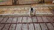
Drills in 2015 at Denison Mines’ Wheeler River uranium project in northern Saskatchewan’s Athabasca basin. Credit: Denison Mines.
Athabasca basin
The structures of the STZ are responsible for many of the geophysical lineament’s underlying the Proterozoic-aged sediments of Saskatchewan’s Athabasca basin. The basement-hosted structures, and where they pierce the overlying sediments, served as favourable traps for uranium-rich fluids. In fact, the Athabasca basin is home to the world’s richest uranium deposits, and accounts for 20% of global supply.
While most uranium deposits are found on the eastern and western sides of the basin — with Cameco (TSX: CCO; NYSE: CCJ) leading the way in their production — explorers continue to probe Alberta’s slice of the basin, however no economic deposits have been found to date.
Diamonds
Diamond-bearing kimberlites have a range of ages in Canada, dating back 2.7 billion years (Wawa breccia diamonds in Ontario) to 55 million years (Lac de Gras in the Northwest Territories). The deposits are typically found in Archean terranes, because the crust reaches a depth where carbon destabilizes and converts to diamonds. The diamonds are brought to surface by volatile-rich magmas, which punch rapidly through the crust, and erupt at surface in the shape of cylindrical-shaped pipes.
In Alberta, 51 kimberlites have been found in three areas: Buffalo Head Hills, Birch Mountains and Mountain Lake. To date, the 81-million to 60-million-year-old Buffalo Head Hills kimberlites have the highest diamond contents, with grades up to 55 carats per hundred tonne.
While new diamond frontiers are being explored near Saskatchewan’s Athabasca basin, most explorers focus on the established Fort de la Corne, Sturgeon Lake and Candle Lake kimberlite fields in the central parts of Saskatchewan, beneath a thin cover of Paleozoic sediments.
In Manitoba, kimberlite-indicator minerals have been found within the young sedimentary rocks, but no diamond-bearing kimberlites have been discovered to date. The province points to its locally thick overburden and complex glacial history as potential challenges for explorers, but highlights the SBZ as a prospective area for diamonds.
Overlying sedimentary sequences
Potash, industrial minerals, coal, oil and gas take the stage for resource development in the Paleozoic and younger sedimentary sequences across Manitoba, Saskatchewan and Alberta. Groundwater associated with oil and gas production is being investigated for lithium-brine potential, with values up to 140 ppm so far reported.
I have been prospecting in north central Alberta for over 20 yrs and fully agree with Lesley Stokes about the hidden mineral potential that underlie specific areas of the Western Canadian Sedimentary Basin. My two partners and myself have
identified anomalous values of gold, silver, boron, diamond indicators and diamonds in north central Alberta. We believe these
sites are associated with and specific to the Snow Bird Tectonic Shear Zone and that part of the craton that underlie
north central Alberta.